Upper Dolpo Trek

Highlights

  • An adventurous trodden trekking route in the unspoiled remote Western part  of the country
  • Explore the last forbidden ancient Buddhist kingdom
  • Trek in the trans-Himalayan region in the rain shadow of Mt. Dhaulagiri and Mt. Annapurna
  • Explore medieval relics, centuries-old monasteries etc, on this trek
  • Witness stunning views of the Himalayan mountains, barren hills, impressive rock formations, vast meadows, and barely fields
  • Come across rich Tibetan Buddhist cultural heritage
  • Visit Sefoksundo lake
  • 45 minutes scenic flight to Nepalgunj

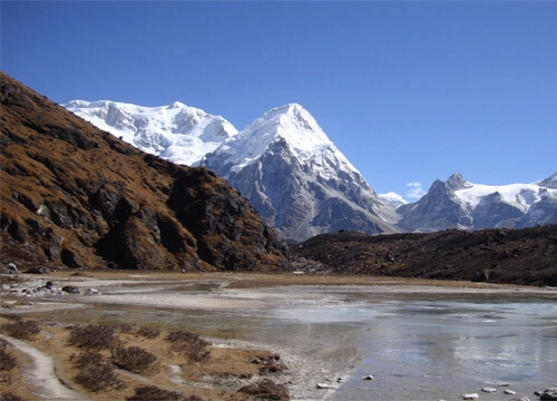
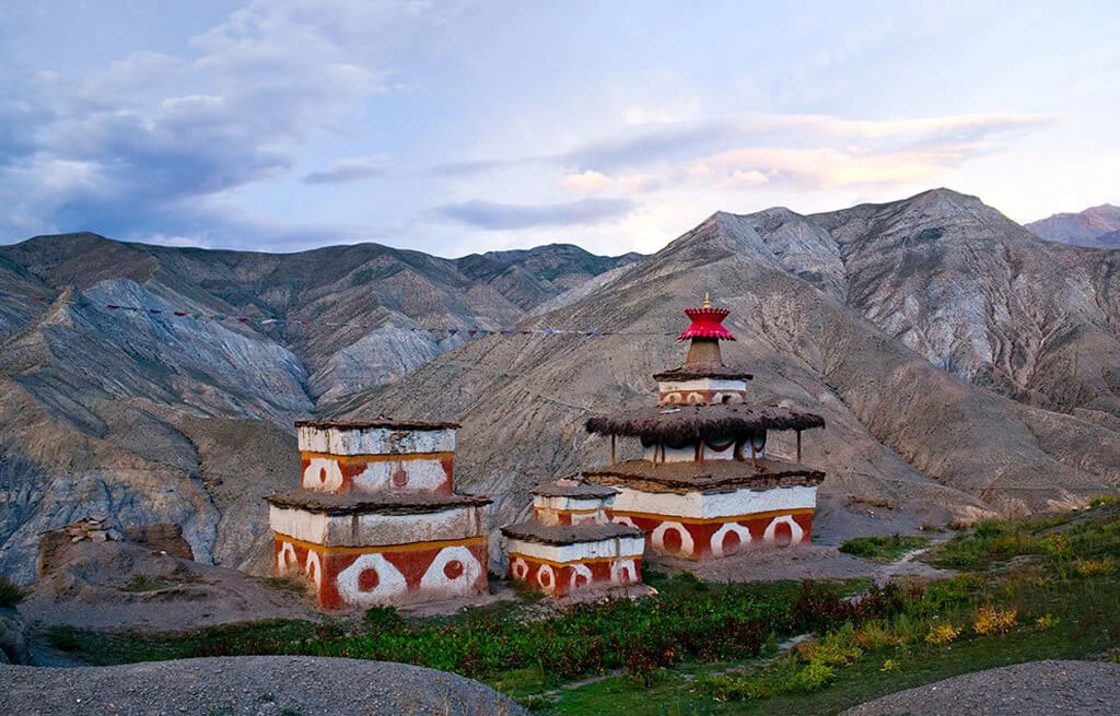
Upper Dolpo Trek takes you to the high and confined valley of Dolpo. It is in Trans Himalayan region of Midwest Nepal. Geologically, upper Dolpo is a piece of  the Tibetan Plateau. This area falsehoods is the remote Shey Phoksundo National Park behind the Dhaulagiri. Shey Phoksundo is the greatest national park of Nepal. The whole locale was shut to trekkers until 1989. Not at all like most different parts of Nepal are the Himalayas. This area is large, dry and cool. This area is merely vegetated with tough scenes where one can encounter the virgin nature. This area is untouched by the advancement and outside impact of any sort. The general population living here who is from Tibetan sources still taking after hundreds of years old Budhhist and Bonpo conventions blended with Shamanistic impacts.

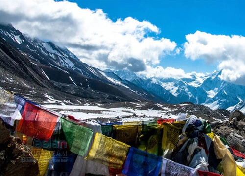
Upper Dolpo Trek starts at Juphal after a 45min  flight from Nepalgunj. At that point we trek to Dunai. It is authoritative headquarter of Dolpo district. Then we go through Sulighat coming to Phoksundo Lake. We trek along the banks of Phoksundo Khola to Shey Gompa through Kang-La pass. Taking after the antiquated Trans Himalayan Trade course we backpedal to Juphal for a flight to Neaplgunj. Then, from Nepalgunj we take flight to Kathmandu. We experience fascinating spots, people groups, valley and pass numerous enormous mountain ranges. Shey Phoksundo national park is home to rich natural life. It includes Musk Deer, Himalayan Blue Sheep and subtle Snow Leopard. We can appreciate the blue water of Phoksundo lake and encompassing Kanjirova range. An astonishing nation of Crystal mountain at Shey Gompa and Ringmo town still has some old religious communities alongside some most delightful view.

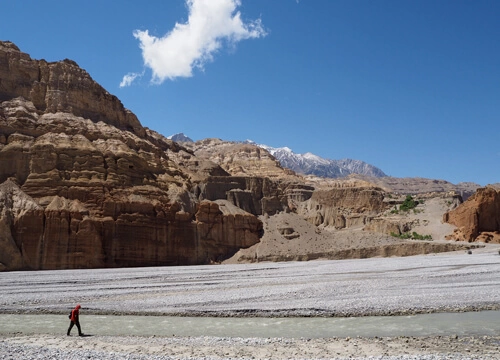
Dolpo is one of the most astounding occupied areas. It is honored with nature and rich culture past nature, yet at the same time once in a while went to outcast. This baffling and concealed area with particular individuals, construction modeling and special light conditions is a picture taker’s heaven. Walk in May in Spring and October-November in Autumn season are best times for trek. Nepal Pioneer Treks & Expedition is glad to operate this trek  for you to make it your lifetime experience

Itinerary
Expand AllCollapse All

Upon on your arrival at the Tribhuban International Airport one of our staff will be there to warm greeting you with beautiful garland that is our respect and the culture to welcome to the new stranger. After welcoming you our staff will transfer to you to the hotel. After your long journey on plane, you may get tired, so be fresh then our manager will come to meet you to the hotel and talk about the plan of your trip details.

  • Accommodation: Hotel
  • Meals: Dinner
  • Max. Altitude: 1300m

Today our tour guide will come to meet you at the hotel at 09.00 AM. The tour guide will introduce you then take you to the world heritage sites. He will describe you about the history, cultures and so on about all the monuments. After visiting the world heritage sites, our manager will meet you again and take a feedback about the day trip, then take you to the most famous typical restaurant for well come dinner to show the cultural program.

  • Accommodation: Hotel
  • Meals: Breakfast
  • Max. Altitude: 1300m

As per the flight schedule for Nepalgunj we transfer to the domestic airport for one hour and half scenic flight to Nepalgung. At Nepalgunj we will have time in the late afternoon or evening to have a look around the town which is situated on the southern Nepal border with India. Here it is quite hot and tropical in character. Stay overnight at hotel.

  • Accommodation: Hotel
  • Meals: Breakfast, Lunch and Dinner

After breakfast in morning transfer to airport for the 45 minute flight to Juphal over the Himalayan foothills, with views of Annapurna and Dhaulagiri peaks to the north. On arriving at Juphal our trekking staffs will receive you, who have walked all the way from Nepalgunj with the camping gear and food supply taking 5-6 days. Here at Juphal a short 2-3 hrs walk from the airstrip leads to our overnight camp at Dunai village (2,850m/9,348ft). Our first day adventure begins with an hour downhill walk through the village below the airstrip, then leading through the terraced fields to the Bheri River and the narrow gorge taking 2-3 hours to camp at Dunai.You can look around the village in the evening and stay overnight thetre.

  • Accommodation: Hotel
  • Meals: Breakfast, Lunch and Dinner

From the camp at Dunai, route diverts from the King Mahendra statue to cross the new suspension bridge and turning west, follow the trail to pass the hospital. The path soon begins to climb up the side of the treeless Thulo Bheri valley, where it crests a ridge and then enters the Phoksundo river valley, finally reaching another ridge which is marked by cairns at 2,499m/7,996ft. During the walk can be seen excellent view of the Kagmara Peak up the valley. This wonderful walk leads to a large side canyon, then descending gently on the long downhill slope through the scattered houses and walnut groves to a stream at 2,810m/8,992ft the trail below the stream leads to Dhera, a winter settlement where people from higher villages keep herds of cows and goats, however the route leads the upper trail climbing to Rahagaon, a Thakuri village at 2,900m/9,280ft, where there is a Gompa dedicated to the local god, Mastha, guardians of this village. Trek from here passes through the lower part of Rahagaon and then descending to the village water supply at the Phoksundo khola. Passing through another canyon, the path heads drop downhill through deep dark forests to a large stream, finally emerging at the entrance to the Shey Phoksundo National Park at Ankhe (2,896m/9,267ft) where we will stay for the overnight camp.

  • Accommodation: Hotel
  • Meals: Breakfast, Lunch and Dinner

The path from this camp leads to small ups and downs along the forested riverbed, then ascending steeply to about 2,900m. The ups and downs can begin to get a bit monotonous, but there are several streams along the way that offer a chance to cool off. The trail eventually leaves the forests and traverses a grassy slope high above the river. You can almost look down between your toes to see the fast-flowing river below. After reaching the river at 2,950m, the trail becomes a collection of rocks and sticks that form a dyke along the river bank. It’s hard to imagine how the local people bring their yaks and cows along this trail.Once you arrive the place ,explore the town then stay over night at lodge.

  • Accommodation: Hotel
  • Meals: Breakfast, Lunch and Dinner

The trail continues along the valley floor to the confluence of the Phoksundo and Pungmo Kholas. After crossing to the western side of the Phoksundo Khola on a wooden bridge, then the path follows the west bank of the Pungmo Khola which leads all the way to Phoksundo Lake 3,500m/11,480ft near Ringmo village. The path passes through a cedar forest and finally to Palam, a winter settlement used by the people of Ringmo village. The houses here are almost buried in the sandy soil. From here our route heads up to open country, at an altitude of around 3,350m/10,988ft. From the ridge one can see the distant views of Phoksundo Lake and a spectacular 300m/984ft high waterfall, one of the highest in Nepal. After a brief stop here with the great views, finally the walk descent through birch forests to the upper reaches of the Phoksundo Khola, and then to the picturesque settlement of Ringmo with its mud plastered chortens and mani walls. From here it is a short walk to the shores of Phoksundo Lake then stay over night there.

  • Accommodation: Hotel
  • Meals: Breakfast, Lunch and Dinner

Today you can sleep longer.A well deserved rest day free from packing, laundry at Phoksundo we can go for a short hike after breakfast to the village of Ringmo and its Tibetan Buddhist Monastery is well worth a visit.Back to hotel after hike then stay over night at lodge.

  • Accommodation: Hotel
  • Meals: Breakfast, Lunch and Dinner

From Phoksundo, trek continue skirting the shore of the lake as it contours on a rocky ledge along the western bank. This unsteady trail suspended on a gangway of wood supported on pegs driven into crevasse in the rocks, signals the remoteness of the area we are about to enter. At the westernmost edge of the lake the path leads through a lush meadow that opens up into the flood plain of the Phoksundo Khola. Then the walk leads through the valley, crossing the river and avoiding the occasional boggy marsh underfoot and then coming to the bank of the river to the overnight camp

  • Accommodation: Hotel
  • Meals: Breakfast, Lunch and Dinner

Today’s first hour walk leads along the level path through a glacial valley that now heads to North. At the confluence of the Phoksundo Khola and another mountain stream, there is an old wooden bridge. Here taking the barely distinct path to the north-east of the valley. There is no trail as such, so it is necessary to clamber over the rocks and boulders and to ford a stream that rushes down the steep valley. A long climb brings us to a sheep meadow where the trail veers up a steep ravine. A hard climb to the top brings to yet another valley where one can see the Kang-La, the pass which will lead towards Shey Gompa. Overnight camp will be just before the pass in a place that Peter Matthiessen christened ‘Snowfields Camp.

  • Accommodation: Hotel
  • Meals: Breakfast, Lunch and Dinner

Morning walk leads up to a steep climb littered with slate towards the pass. The climb is quite strenuous, especially on the slate screed. From the top of Kang-la 5,360m/17,581ft, there are excellent views down upon a large valley which is bisected by a gushing river. On descending steeply to the valley floor, then the path leads a long meandering trek along the banks of the river, crossing and re-crossing it several times. There are the mud caves lining the hills overlooking the river and we pass through meadows where hairy yaks, hundreds of sheep and domestic mountain goat (Chengra) can be found grazing as well near the odd nomadic hut of the herders. A red Chorten heralds our arrival at Shey Gompa 4,500m/14,760ft where a quaint wooden, log bridge leads up to our destination at Shey Gompa compound for our overnight camp.

  • Accommodation: Hotel
  • Meals: Breakfast, Lunch and Dinner

Another well earned rest day for local hike around Shey meaning crystal, this monastery is also known as the Crystal Mountain (well described in the Peter Matthissen classic novel Snow Leopard). The lama of Shey resides at a red hermitage known as Tsakang Gompa which is north of Shey. It is rather a retreat than a monastery. Tsakang had been a meditation center of many famous lamas from Tibet. Shey Gompa belong to the Chaiba community, followers of great saint Padmasambhava, known as Guru Ringpoche and Kagyu sects. It was the first Kagyupa monastery and its founder was the lama Tenzing Ra-Pa, built during the 11th century. Shey is famous for its ancient pre-Buddhist culture the Bon Po. In Dolpo the ancient Tibetan way of life combines animism with the teaching of Buddha. Drutup Yeshe first introduced Buddhism in the Dolpo valley. Hundreds of years ago he came to Dolpo encountering a wild people whose supreme God was a ‘fierce mountain and nature spirit’. Crystal Mountain is to the east of Shey Gompa it is one of the strangest mountains, as its contorted cliffs are laced with quartz and embedded with a rich variety of marine fossils. Shey Gompa stands above the confluence of Kangjunala and Yeju Nala River. Near the confluence there is a group of prayer mills turned by water wheels. Each year people from all over Dolpo region travel great distances to attend the festival at Shey and to complete the circuit of Crystal Mountain. This is an amazing trip to here that certainly makes this trek as special as only few Westerners have ever ventured up to Shey gompa.

  • Accommodation: Hotel
  • Meals: Breakfast, Lunch and Dinner

The day begins by following a pleasant trail amidst juniper which descends into a grey, stony canyon. Then the path begins to zig zag over bare rocks and coarse eroded soil until it eventually brings us to the top of Saldang-la 5,200m/17,056ft. The subsequent descent towards the north which is long and tiring but we finally come upon the welcome sight of pastures of grazing yaks and sheep, and nomadic tents made from yak hair. This signals our approach to Namduna Gaun 4,800m/15,744ft. Like Shey, the Namgung monastery is of the Karma-pa sect. The monastery, a red stone structure, is built against the backdrop of a cliff on the north wall of a gorge. The red and white colors of the gimpy and its stupas are the only color in this stark landscape. The village itself consists of only six stone houses and has terraced fields on both sides of the tributary, which flow down to the Nam Khong valley. The economy of the region is based on agriculture, animal husbandry and trading. In Dolpo only one crop a year can be grown and this is mainly barley. In some villagesâ, buckwheat, oil seed, potato and radish are also cultivated. Recently the main cliff temple collapsed and the villagers have now built a beautiful new monastery in the village itself.

  • Accommodation: Hotel
  • Meals: Breakfast, Lunch and Dinner

On leaving the Namduna Gaun our route leads to a climb up a scree slope. Further on it begins a long traverse along some dusty barren mountains. After 3-4 hours of hard climb, Saldang 3,620m/ 11,874ft appears below on a plateau high above the Nam Khongmala. It has a picturesque appearance. Saldang is the largest village of the inner Dolpo area. Though the village lies at about the same altitude as Ringmo it is totally different then Ringmo, a Himalayan village is situated below the tree line while Saldang belongs to the arid zone of the Trans-Himalayan Tibetan plateau. The village stretches for nearly two kilometers on an open slope. Saldang consists of five villages having about eighty well built houses with nearly six hundred people. Saldang is a prosperous village not only agriculturally but also for its strategic location on a trade route to Tibet. After the Chinese invasion of Tibet in 1959, trade with Tibet was virtually stopped. It has been restored to some extent through the barter system by which Tibetan salt reaches mid-Nepal. The Drokpa people from the western plains of Tibet collect salt from the dried lakes north of Tsangpo.

  • Accommodation: Hotel
  • Meals: Breakfast, Lunch and Dinner

Journey from here diverts further far north to the last unexplored area by westerners or by any other commercial adventure trekking companies. The trail follows the Nang Chu river most of the way on this wild barren windswept terrain. Walk begins along the fairly gradual path with few ups and downs slope and then passing through the small settlement of Tiling and Lurigaon till we reach to our overnight camp at Yangze also known as Yangtsher, just before Yangze near Lurigaon. Here we cross the tributary Panzang river, a short walk from here brings us to an unexplored region of Yangze 4,960m/16,267ft and its very old Bon-Po Monastery for the overnight halt with time for exploration around the villages and the Monastery.

  • Accommodation: Hotel
  • Meals: Breakfast, Lunch and Dinner

From Yangze there are two trails that connect Sibu (4,560m/14,957ft), the long way trail heads due west, passing through the very remote villages of Nishalgaon and further past Shimengaon. To save time and energy we will retrace the path back towards Saldang village which will be much easier and shorter than the other North western route. From Saldang the trail following the river bed we pass through terraced fields, Stupas, Chortens, heaps of Mani stones and a Chaiba monastery, then passing through the Namdo village which is also prosperous with about sixty houses having nearly 400 inhabitants. It stretches for more than 5 km on the high slopes to the left of Nam Khong Khola. The Namdo monastery is located near the river bed. Our journey continues further down the river for another two hours to camp near the small settlement of Sibu.

  • Accommodation: Hotel
  • Meals: Breakfast, Lunch and Dinner

The trail follows the Nam Khong Khola for a while on the morning walk coming across caravan of laden yaks that are on their way towards Tibet border. After days of following the same river, finally we part turning east till we arrive at the confluence of two small tributaries, from here our walk leads to a steep climb to the bottom of Jeng la (4,900m/16,072ft), where we stay for the overnight on a nice meadow.

  • Accommodation: Hotel
  • Meals: Breakfast, Lunch and Dinner

Morning trek leads to two hour climb towards the top of the Jeng La (5,090m/16,695ft). An excellent view of snow ranges emerges to the south. The north face of the Dhaualgiri massif shines in the morning light. After a wonderful moment here at the pass, our walk leads to descend on the rough path towards Tarap valley. By afternoon we come to the green valley which leads us on the pleasant track down towards Tarap Chu. Tarap is a fascinating valley with vast plains in high mountains. It extends twenty kilo meters along the river. Tarap Chu is having ten villages with its cultivated fields and many Gompas, Chortens of both sects. We stop for the night at the Tokyu monastery (4,200m/13,776ft). This monastery also belongs to the Chaiba sect.

  • Accommodation: Hotel
  • Meals: Breakfast, Lunch and Dinner

Today, the route leads eastward along the downhill course of Tarap Chu in a plain valley with patches of lush ,verdant grass on both sides of the river which is completely different from other parts of inner Dolpo. There is also a marsh which is a common feature in the Desert Mountains of Tibet and the Ladakh Himalaya. In this valley both Bon Po and Chaiba sects reside together in harmony. After a short trek on this beautiful valley we come to Dho Tarap (4,040m/13,251ft) for the overnight camp with ample time to visit around the villages. This village is surrounded by an irregular stone wall. In Dho, about 40 houses are divided into three clusters and built in a haphazard way inhabited by few Tibetans and mostly Magars hill tribe of Nepal who have lived here for many generations.

  • Accommodation: Hotel
  • Meals: Breakfast, Lunch and Dinner

Today, we have a full rest day or exploration of local areas. During the visit you will have an opportunity to make friends with the people of Dolpo. They wear home spun clothing that is sometimes dyed maroon and they prefer Tibetan style somba (boots with upturned toes) for footwear. Men and women often wear both religious amulets and strings of coral and turquoise. The villagers are both Bon Po and Buddhist of Nyingmapa sect. The Buddhist gompa is the nearest one to the campsite, the Bon Gompa is further 40 minutes walk.

  • Accommodation: Hotel
  • Meals: Breakfast, Lunch and Dinner

Today can be quite a long day or moderate walk depending upon the choice of several different campsites so the itinerary can be as flexible as you like. From the quite bare country around Tarap, we descend towards a wide valley which eventually narrows into a gorge. We walk along the juniper bush and wild rose, typical of dry inner Himalayan valleys, to just above the tree line. On this route we might see herds of blue sheep. By the afternoon time we reach at the confluence of the Tarap Chu and the Lang Khola, a stream that joins with Tarap River from further east. We will make our camp on a nice meadow, this place is also known as Kamakharka (3,800m/12,464ft), while our porters will perhaps take shelter in a nearby spacious cave.

  • Accommodation: Hotel
  • Meals: Breakfast, Lunch and Dinner

This morning again continues down the gorge of the Tarap River, at times alongside it, rising high above on a trail built from the steep slopes might come across people from Dolpo taking their herds to lower pastures for the winter. There are many possible campsites by the river. This will be one of the exciting days of this trip walk, as the valley becomes so narrow in a deep gorge that in some places we can jump from one side to another. Sometimes there is no trace of any path and we have to walk across the stone slabs fitted on logs in between the walls which act as a bridge. The gorge also provides unexpected adventure and thrills. At some places, the bridges are either damaged or washed away and we may be forced to cross the icy torrent on foot. Finally, reaching to the camping spot beside the Tarap khola at Khanigaon (3,150m/10,332ft) we stop for an overnight stay.

  • Accommodation: Hotel
  • Meals: Breakfast, Lunch and Dinner

Today from this camp path follows an indistinct trail to the village of Lalberi. Then passing through an area of impressive forest, before descending into another gorge our walk continue following the river again downstream to reach Tarakot where colorful terraced fields greet us. Tarakot (2,537m/8,321ft) is an old fortress town known by the local people as Dzong, meaning ‘fort’. Before the Gorkha dynasty Tarakot was the capital and had a Dzong. The famous Sandul Gompa lies about 8 km east of Tarakot and at the junction of Barbung Khola and Tarap Chu. It stands on a knoll to the south of Bheri River and at one time supervised collections of tolls for the trading caravans traversing an area called Tichu Rong. It is possible to camp by the river about 150 meters below Tarakot, near the police post or we climb a steep hill for over an hour to the small village on a spur on the other side of a valley opposite Tarakot. There are Chortens and a Gompa here on the edge of a grassy plateau, with an interesting solitary tree.

  • Accommodation: Hotel
  • Meals: Breakfast, Lunch and Dinner

The walk continues beside the Bheri River in a tremendous gorge with pine trees and an ingenious path built about seven meters above the river. On reaching Dunai (2,140m/7,019ft) after completing the circuit with time for celebration, particularly as bottled beers are available in Dunai or else try the local brew.

  • Accommodation: Hotel
  • Meals: Breakfast, Lunch and Dinner

We retrace the journey back to Jhuphal, which is a short distance walking along the Bheri River to the small airstrip for the last overnight camp of this great memorable adventure.

  • Accommodation: Hotel
  • Meals: Breakfast, Lunch and Dinner

Early morning, a short scenic flight for thirty five minutes to Nepalgunj, over the Himalayan foothills overlooking stunning views of the main peaks including Annapurna and Dhaulagiri to the north. On arrival at Nepalgunj depending upon the connecting flight schedule to Kathmandu. If it is in the afternoon have time for few hour refreshments in the comfort of the Hotel Batika or similar at Nepalgunj. Then connect with the flight back to Kathmandu.

  • Accommodation: Hotel
  • Meals: Breakfast, Lunch and Dinner

This pleasant day you may have full day at leisure and either relax at the hotel or explore the Thamel and overnight at hotel.

  • Accommodation: Hotel
  • Meals: Breakfast and Dinner

Today our driver will drop you to the International Airport for the final departure. We wish you had a nice and safe journey back home.

  • Meals: Breakfast
Includes/Excludes
Includes
  • Two nights accommodation in Kathmandu with twin sharing at tourist standard hotel (Bed and Breakfast)
  • All Ground and air transportation. Pick up and drop.
  • Full board meal 3 times a day (B+L+D) during the trek days including tea & coffee (served in a cup).
  • English speaking trekking guide who has been authorized by the Nepal government and necessary number of porters (According to the group size) with their insurance, salary, accommodation, and meals.
  • Welcome and farewell dinner in Kathmandu with Cultural show. (Ethnic music and dance)
  • All the necessary official documents, TIMS Permit, Trekking Permit, Special Permit etc.
  • Sleeping bags and down jackets if necessary.
  • First Aid kit.
  • Trekking Route map.
  • Insurance of Guide and Porters.
  • All required local and government tax.
Excludes
  • Nepal Visa fee and International flight.
  • Meal except for Breakfast in Kathmandu. 
  • All personal expenses such as bar bills, water, extra tea/coffee, snacks, battery re-charge, laundry service, etc.
  • Personal clothing and gears.
  • Tips to guide and porters.
  • Cost raised by flight cancellation, emergency rescue charges, landslide, weather, political unrest, illness, re-routing etc which are not under our control.
  • Monument entrance fees.
Additional Information

Upper Dolpo trek best time

Like any other trekking route in Nepal, the best time to do the Upper Dolpo trek is in spring and autumn. Because the Upper Dolpo region is situated in the rain shadow area, you can do this trek during monsoon season too. You may face rainfall at the start of the journey, but there is no rainfall above tree line. 

Trekking in spring (March to early May) lets you see rhododendrons and junipers blooming all over the place. The fragrance of teeming vegetation and the warm weather is fantastic. The days slowly begin to get longer, and the temperature ranges between 15°C to 23°C. 

Trekking in autumn (October to November) lets you be part of the biggest festival in Nepal. There is festivity in the air, and the cities are well-decorated with bazillions of lights. The weather is stable and mild, like in spring. The mountain views are crystal clear, and the temperature ranges between 10°C to 15°C. 

Upper Dolpo trek accommodation

You will stay overnight in tea houses along the Upper Dolpo trekking route. Tea houses are a very basic kind of accommodation operated by villagers. You get shared rooms and a washroom. Better carry a sleeping bag for more comfort and warmth. Single rooms are available only if you inform us priorly and pay extra. You will get to experience the mountain lifestyle during the Upper Dolpo trek. 

Meals

The Upper Dolpo trekking route offers Nepali and Tibetan meals mostly. The teahouses at the start of the trek have several western dishes like burgers, pasta, sandwiches, oat, etc on the menu. With the progress of the trek, you will mostly get dal bhat, momo, thenduk, Tibetan bread, soup, porridge, etc. Our Upper Dolpo trek package includes three meals a day, and all meals are given as per the menu of the tea houses.

It is better to carry your favorite snacks for the trek. There is also decent availability of beverages. Boiled drinking water is provided in the teahouses free of cost. For additional safety, you can use a water purification tablet. 

Group/private joining

We have a few fixed departures for the Upper Dolpo trek 2023 that you can join as a solo traveler and trek with other fellow trekkers from all around the world. Or you can do a private Upper Dolpo trek with your loved ones. Trekking in a big group reduces the per-head cost of the package.

Travel Insurance

It is better to have travel insurance if you are thinking of doing the Upper Dolpo trek. The Upper Mustang is a very remote area with not good hospital. The trail has no access to any medical facility. In case of any medical emergency, we have to air evacuate to a hospital in Kathmandu or Pokhara. Without travel insurance, it gets very challenging for us to provide rescue promptly. Therefore, we kindly request to buy travel insurance that covers air evacuation.

FAQs
  • Upper Dolpo trek takes 28 to 30 days to complete. If you like the places more, you can extend your trip?

  • Upper Dolpo trek start from Juphal after 45 minutes flight from Nepalgunj.

  • Upper Dolpo is located in Western part of Nepal at Trans Himalayan region.

  • Yes, there is a very famouse lake called Sefoksundo.

  • Yes, this trip is very far way from Kathmandu and this is remote area so that you need guide for your safety.

  • Definitely, you need the travel insurance just incase of emergency, helicopter evacuation and accidental case. It will much easier to claim for yourself from the insurance company.

You Make Also Like
Similar Packages